


Contact
Dr. Detlef Thürkow
detlef.thuerkow@geo.uni-hal...
Von-Seckendorff-Platz 4
06120 Halle (Saale)
WebGIS Development

Table of Content
Introduction
Thanks to sophisticated information technology, spatial data processing is increasingly carried out in web-based, decentral systems. The development of such Spatial Data Infrastructures (SDI) is pushed forward rapidly by various actors.
In this context, the Institute of Geosciences at the University of Halle is developing Web-GIS - applications which are fit for the needs of todays web-based spatial data processing.
Development Goals and Design Considerations
The development goals and design considerations are chosen as follows:
- Fully web-enabled (a.k.a web-only) clients
- Service-oriented architectures
- Standards-compliant implementation featuring various W3C-standards (XHTML, XML, JS/EcmaScript, SVG) and OGC-standards (WFS + GML3, WMS)
- Focus on cross-browser compatibility and high interoperability
- High quality of graphical output due to vector-based graph engine (SVG)
- Implementation of primary and secondary data model interactions
- Efficient, native XML-based attribute- and metadata storage and mangement
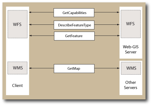
Web-GIS Prototype Architecture
The Web-GIS prototype implements two parts:
- A (server-side) Web Feature Service (WFS) interacts with clients and processes queries, retrieves and stores data to DBMS and generates WFS/OGC-conformal query responses
- A client, implemented as a JavaScript Class, is provided to query data, generate WFS requests and visualise geodata. The client implements WFS and WMS interfaces and can therefore be used independently from the prototype's server-side implementation

Simplified Web-GIS Architecture.
Stage of Development
Server-Side Implementation
The current server-side implementation can be described as following:
- Service (PHP) processing mandatory, XML-encoded HTTP POST requests as required by WFS standard (currently GetCapabilities, DescribeFeatureType and GetFeature-Request)
- Parsing of selected optional request parameters (maxFeatures)
- Filter
- SOAP interface (currently for selected features, SOAP for WFS requests as alternative request method under development)
- Data storage and retrieval capabilities (to a PostgreSQL/PostGIS database for spatial data, to eXist native XML database for attributes and metadata) according to Application Schema
Implemented interfaces and currently served requests of the Web-GIS Prototype.
Client-Side Implementation
The current development stage of the clients can be summarized as follows:
- Geodata visualisation with SVG and Java Script
- WFS and WMS interfaces
- XPath implementation to parse Application Schemas and server responses
- Various caching mechanisms to improve the application's performance
- Secondary data model interactions (pan, zoom etc.)
- Configurable map sizes
- Interactive map legends
- Support of GML FeatureStyles if provided by the server

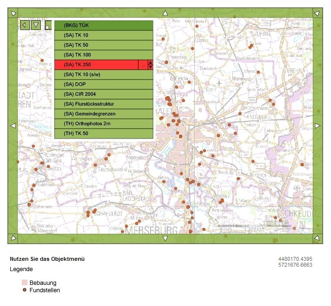
Client with map frame and legend. The viewer shows part of the city of Halle. The buildings layer is served as WFS/GML3 from a PostGIS database. Underneath are two blended WMS layers (DOP, Topographic Map) served by the Landesamt für Vermessung und Geoinformation Sachsen-Anhalt.
Client with interactive menu generated in SVG to choose between several WMS services.